
Trona Desert Trail
- OTG Crew

- Oct 28, 2021
- 7 min read
Updated: Dec 22, 2025
The Trona Desert Trail traverses some of southern California's most iconic desert landscapes providing an unforgettable mix of desert landscapes, strange rock formations, and technical trails.


Route Overview
Trip Length & Seasons
Adventure Rating: Epic Trip Length: 239 miles, 4-6 days Season:Typically year round, but the shoulder seasons of Spring and Fall provide the best weather. During periods of heavy snowfall, Mengal Pass may be impassable.
Digital Maps & GPX Files
Download Digital Mapping Files
If you need help working with digital mapping and GPX files, please check out our FAQ section.
Technical Ratings & Terrain
Avg Technical Rating: 3
Peak Technical Rating: 5
Typical Terrain: Graded dirt BLM roads, sandy washes, and some rockier and technical jeep tracks through Red Rock Canyon State Park and Goler Wash/Mengal Pass. Expect a lot of cliff exposure through South Park Canyon.
Recommended Vehicle / Moto / Adventure Vans
Recommended Vehicle: High clearance 4x4
Recommended Moto: A dual sport bike is recommended given the rocky and technical nature of the route's jeep tracks.
Adventure Vans: Sprinter 4x4s can manage the section through Jawbone Canyon and the section through Trona Pinnacles (starting at Searles Station Cutoff Road). We recommend skipping the rest of the route beyond Trona Pinnacles.
Alternative Routes
n/a
Camping Recommendations
Dispersed camping is permitted along most of this route, especially on land managed by BLM and Death Valley National Park (Butte Valley Road vicinity. Here's a short list of our go to campsites and locations for camping:
Trona Pinnacles (of course!)
Last Chance Canyon (in and around the Bickel Camp area)
Geologist Cabin and Butte Valley Road
Warm Springs Camp
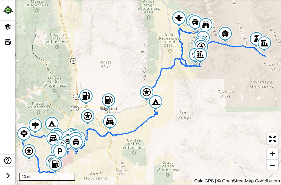
Discovery Points
DP1 - Jawbone Canyone
DP2 - Pacific Crest Trail
DP3 - Los Angeles Aqueduct
DP4 - Red Cliffs
DP5 - Black Rock Canyon
DP6 - Cudahy Ghost Camp
DP7 - Holly Ash Mine
DP8 - Bickel Camp
DP9 - Burro Schmidt Home
DP10 - Burro Schmidt Tunnel
DP11 - Trona Pinnacles
DP12 - South Park Canyon
DP13 - Briggs Cabin
DP14 - Chicken Rock
DP15 - Rita's Cabin
DP16 - World Beater Cabin
DP17 - Pleasant Canyon
DP18 - Ballarat Ghost Town
DP19 - Lotus / Keystone Mine
DP20 - Barker Ranch
DP21 - Mengal Pass
DP22 - Geologist's Cabin
DP23- Striped Butte
Land Managers & Other Resources
Permits & Papers
You will need to pay day use fees for both Red Rock Canyon State Park and Death Valley National Park.
Adventure Badge
OTG has partnered with All Roads Taken to offer an adventure badge for this route.

Route Details
Anyone who lives in California, and especially those who live in the Southland, know that the desert in Southern California is where folks go to recreate and camp during fall, winter, and much of spring. To those who haven't woken to the brilliant orange and red hues of a desert sunrise or heard a trio of coyotes cackle in the distance, the desert may seem a bland and lifeless environment. Hardly—the desert is alive with flora and fauna, and a rich history of Native Americans and early pioneers who mined these hills, mountains, and canyons, looking to strike it rich.
The Trona Desert Trail is named after one of Southern California's most iconic desert landmarks, the Trona Pinnacles, which sit roughly in the middle of the overland route. The namesake pinnacles form over 500 tuff spires, some rising up to 150 feet. One feels as if they're on a lunar or alien landscape, especially under the moon and stars. But there's much more to the Trona Desert Trail than just the Trona Pinnacles. Along the way, you'll capture views of the alpine slopes of the southern Sierra Nevada, numerous mines and mining camps, red rock canyons, and rock-strewn technical trails like Goler Wash and Black Rock Canyon.
We begin our adventure in the desert lowlands at Jawbone Station, where Jawbone Canyon meets the Aerospace Highway (Highway 6). Jawbone Canyon and the surrounding BLM land are filled with numerous OHV staging areas and campsites. Expect a lot of Jeep, ATV, moto, and SxS traffic on the first leg of the route. Numerous side roads split off from Jawbone Wash, many of which contain hidden campsites deep in the side canyons—but expect the best campsites to be taken, especially on a weekend. That's just fine, though. We'll continue our journey up the mountain. The pine-filled slopes of the southern Sierra come into view—this is where the mighty Sierra meets its southern terminus. If you're up for a bit of a hike, the Pacific Crest Trail (DP2) crosses the road just below Mayan Peak and then again as you loop your way back around to the pavement of Highway 6. With its sandy and wide graded roads, the loop through Jawbone Canyon is a nice warm-up, but hardly a precursor of what's coming soon.
Next up, Red Rock Canyon State Park. Head over to the parking lot and check out the Red Cliffs (DP4), which have a mini Bryce Canyon-esque feel with their numerous pale orange and red hoodoos. Leave the parking lot and continue on your way. Things start out simple enough on nice dirt but pick up quickly as you close in on Black Rock Canyon (DP5). The Jeep crowd loves Red Rock Canyon State Park, and you'll soon see why. Trails like Opal Canyon, Black Rock Canyon, and Last Chance Canyon are littered with cool rock features, eroded jeep tracks, and some nice little challenges along the way. Novice off-roaders may want a spotter to navigate some of the trickier sections, but experienced drivers can likely make it through on their own. Once you drop into Last Chance Canyon, Cudahy Camp (DP6) is the first of a series of mines and old mine camps in the area. Some of our favorites include the Dutch Cleanser Mine, Holly Ash Mine (DP7), and Burro Schmidt Tunnel (DP10). Many of the mines have open shafts that can be explored (always do so with caution), and the Holly Ash Mine shaft is big enough for a vehicle to drive in! Bickel Camp (DP8) was named after Walter Bickel, who once lived and prospected this section of Last Chance Canyon. Once open to the public, Bickel Camp's current status is unknown at this time.
After working your way through the Last Chance Canyon mining district, the route circumvents the scenic El Paso Mountains and wilderness. We'll follow the graded and well-kept BLM roads across Highway 395 and over to the Trona Pinnacles (DP11). If there's one place that we'd camp along the route, it'd be Trona Pinnacles hands down. At the very least, you've got to explore the numerous roads that snake their way around and through the 500+ pinnacles. Unlike Alabama Hills up Highway 395 (another popular camping area), Trona Pinnacles covers a huge amount of area, and even with hundreds of other campers, you can always find a nice site comfortably away from any neighboring campers. Brush up on your night photography and drone flying skills—both favorite pastimes at Trona!
Follow the dirt on Pinnacles Road until it meets the pavement of Trona Road and head north. We'll take BLM Road 168 over the mildly technical Manly Pass, which is a nice warm-up for what's to come as we make our way up Goler Wash. But before we hit Goler Wash, we'll do a loop through the rugged South Park (DP12) and Pleasant Valley Canyons (DP17). The drive up South Park Canyon is incredible and a bit nerve-racking, especially once you reach the famed Chicken Rock (DP14)—take it slow, and you should be fine! The loop features a number of well-kept cabins and mines like Briggs Cabin (DP13), Rita's Cabin (DP15), and World Beater Cabin (DP16). Be sure to check the views from atop the mountain, which looks down on Striped Butte several thousand feet below. Things get a bit easier when descending Pleasant Valley Canyon, but the views and topography are no less impressive. Once you reach the valley floor, be sure to stop by Ballarat Ghost Town (DP18). Ballarat was a boomtown established in the 1890s when miners flocked to the desert in search of gold. Now all that remains are some dilapidated old buildings and relics of the town's mining past.
Retrace your tracks back south until reaching the intersection to Goler Wash. Goler Wash Road is filled with rocks and boulders of all shapes and sizes. Expect to be slow-going for several miles, and while this trail is rated as a 5-6 (depending on who you ask), a 4x4 with a 2" lift should be able to make it through just fine. There are a couple of cool stops along the way before reaching Mengel Pass. First is the old Lotus Keystone Mine (DP19), with its old stone building and various pieces of rusted mining equipment. About two miles up the mountain sits the infamous Barker Ranch (DP20), once the criminal hideout of Charles Manson and his followers. You'd think nobody would find you in the canyons above Death Valley, but Manson and his followers caused such a raucous that they caught the attention of local law enforcement, and the rest is history. If you're a fan of giving yourself the creeps, consider spending a night at Barker Ranch—better yet, do it alone and sleep in one of the cabins. If you pull it off (we certainly have no plans to), we'd love to see some photos and video!
Once over Mengel Pass, you'll descend into Butte Valley. Hook a left over to the old stone Geologist's Cabin (DP22), built by a local miner known as Panamint Russ in the 1930s while he mined the surrounding mountains for gold. If you're wondering why it's called Butte Valley, just look downslope to the massive Striped Butte (DP23) that juts out from the narrow desert basin. The route works its way back down to lower elevation, passing a few more mines along the way until finally reaching its terminus in the Badwater Basin (the lowest point in the lower 48) and Badwater Road.
If you're looking to continue your adventure, you're in luck. OTG's Death Valley Adventure Route picks up in Badwater Basin. So if you're looking to spend another 4-7 days on the trail, just head north and continue along the route.
Terms of Use: Should you decide to travel a route that is published on Overlandtrailguides.com, you do so at your own risk. Always take the appropriate precautions when planning and traveling, including checking the current local weather, permit requirements, trail/road conditions, and land/road closures. While traveling, obey all public and private land use restrictions and rules, and carry the appropriate safety, recovery, and navigational equipment. The information found on this site is simply a planning resource to be used as a point of inspiration in conjunction with your own due-diligence. In spite of the fact that this route, associated GPS track (GPX and maps), and all route guidelines were prepared under diligent research by Overland Trail Guides, the route accuracy and current conditions of roads and trails cannot be guaranteed.


Ran this entire route in Mar/Apr 2024. This is a fun route with great views and challenging trails. DP1 to the Trona Pinnacles had a few steep sections, but for the most part the trails are sandy and fast. After the Pinnacles and just north of Trona, make sure to take the Fish Canyon Excape Trail over the Argus Range to Panamint Valley. The steep climbs/decents/knife-edge trails shouldn't be missed. Once in Panamint Valley, I would recomend doing the Pleasant Valley loop clockwise from Ballarat. Make sure that you take the alternative route to the east around the beginning of Pleasant Valley or you will deal with the 3-4 ft washed out trail in a jungle of vegitation.…
Did Red Rocks-->Trona over Thanksgiving 2022 in a '02 Ford Excursion on 35" tires with a rear locker. Managed to go an expedited version of Ricardo Campground to Trona Pinnacles in one lonnnng day. Day two we just went on Pavement up into DVNP. Wouldn't recommend for a Sprinter, but decently built fullsize rigs would do ok as you're ok with potential minor scratches and dents.
Started out at Ricardo Campground, which has some cool scenery, is reasonably quiet, not too crowded as long as no one takes the spot right next to you.
There are some decently challenging obstacles just past DP5 coming out of Black Rock Canyon and DP6 coming out of Cudahy Camp. Did them without issue,…
Looking at the trail, where exactly does this route enter into Mexico? "Passports, Permits & More: You will need a passport and Mexican vehicle insurance to cross the US-Mexico border. Check Bajabound.com for the low down on vehicle travel in Mexico. Gates are becoming more and more of an issue throughout Baja, and it's possible you may encounter a local (or group) manning a gate and demanding permits or payment. Most people are able to pass without issue, but if you're traveling on a weekend, one of the local ejidos or a rancher may closer their gate in hopes of shaking down off road travelers for a few bucks. " JK, nice track.
Hi Traxx, this trip sounds amazing. Thank you for posting it. Thinking about going in March but only have two nights for the trip. Where would you suggest camping first and 2nd night. Sounds like Trona pinnacles is a great spot. But not sure if I can make it there night 1.