
Shasta-Trinity Backcountry Discovery Trail
- OTG Crew

- Jun 1, 2020
- 6 min read
Updated: Dec 30, 2025
Many say the Pacific Northwest begins in the far northern reaches of California; a place that locals adoringly refer to as the State of Jefferson. Largely disconnected from the population centers to the south, it's a region filled with emerald forests, wild rivers and streams- where the granite monoliths of the northern Coastal ranges meet the lava flows and volcanic peaks of the Cascades.
Route Overview
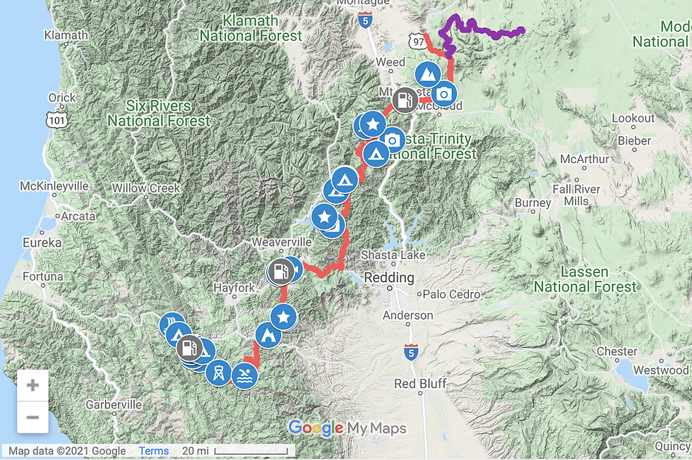
Trip Length & Rating
Adventure Rating: Epic Trip Length: 3-6 days, 257 miles miles Season: Late April - November (depends on snowpack on Hull Mountain)
Technical Ratings & Terrain
Avg Technical Rating: 2
Peak Technical Rating: 4
Typical Terrain: Dirt forest service roads, some pavement, and a short stint on a rocky jeep trail. Tamarack Lake, which is a short out-and-back trail is the only section of trail with a rating of 4.
Recommended Vehicle / Moto / Adventure Vans
Recommended Vehicle: Stock 4x4 or AWD Crossover with AT tires
Recommended Moto: Mid-weight and big adventure bikes should have no problems on this route. Big Bikes should skip the out-and-back to Tamarack Lake.
Adventure Vans: Sprinter 4x4s are good to go. Sprinters may not be well suited for the short out-and-back jeep trail to Tamarack Lake.
Fuel, Provisions, and Recommended Gear
Fuel:
Ruth Lake to Douglas City - 105 miles
Douglas City to town of Mt Shasta - 115 miles
Mt Shasta to end of track and then take Hwy 97 to Weed - 50 miles
Provisions: Provisions can be obtained at/near all fuel stops along the route. Gear: no specialized gear is recommended for this adventure.
Alternative Routes
Mud Creek Bypass Distance: 23 miles Technical Rating: 1 In recent years, the concrete culvert crossing Mud Creek has washed out making the creek impassable, and as of 2024, it's unclear when the Forest Service will fix the creek crossing. Use this alternative track to get around mud creek and back onto the route.
Camping Recommendations
Dispersed camping is permitted through the national forest, but some of our favorite campsites include:
Hobart Creek (just south of the NF campground is a lakefront campsite at Ruth Lake)
East fork of the Trinity where it meets Trinity Lake
Bear Flat (East fork of the Trinity)
Tamarack lake
Pickett Peak Campground (dispersed)
Cliff Lake (rocky jeep track similar to Tamarack Lake)
Gumboot Lake Campground
Cliff Lake
The southern flanks of Mt Shasta (dispersed camping)
Shasta view (north of Mt Shasta off of Hwy 97)
Discovery Points
DP1 - Ruth Lake
DP2 - Mad River
DP3 - Pickett peak Lookout
DP4 - Horse Ridge Lookout
DP5 - South Fork Trinity River
DP6 - Hall City Cave
DP7 - Deerlick Springs Outpost
DP8 - Browns Creek
DP9 - Douglas City
DP10 - Trinity River (main fork)
DP11 - Clear Creek
DP12 - Trinity Mountain Heliport & Viewpoint
DP13 - Trinity Alps
DP14 - Trinity Lake
DP15 - East Fork Trinity River
DP16 - Trinity River Gold Rush
DP17 - Carville Hotel & Stage Stop
DP18 - Alpen Cellars Winery
DP19 - Tamarack Lake
DP20 - Tamarack Jeep Trails
DP21 - Grey Rocks
DP22 - Castle Crags View
DP23 - Gumboot Lake
DP24 - Headwaters of the Sacramento River
DP25 - Mount Eddy
DP26 - Lake Siskiyou
DP27 - Town of Mt Shasta
DP28 - Mount Shasta
DP29 - Shasta Scenic Loop / Road 31
DP30 - Mud Creek water crossing
DP31 - Military Pass
DP32 - The Whaleback
Permits, Permits & Other Resources
Permits & Papers: n/a
Resources:
Digital Maps & GPX Files
Download Digital Mapping Files
If you need help working with digital mapping and GPX files, please check out our FAQ section.
Adventure Badge OTG has partnered with All Roads Taken to offer an adventure badge for this route. >> Buy your adventure badge today!

Route Details
In the 1990s and into the 2000s, the US Forest Service, in association with the California State Parks OHV Division, created the California Backcountry Discovery Trail. In reality, the BDT (Backcountry Discovery Trail) was actually a series of independent overland routes that crossed the public lands of Plumas NF, Lassen NF, Modoc NF, Mendocino NF, Six Rivers NF, and Cow Mountain (BLM) that could sometimes be interlinked. For whatever reason, the USFS abandoned its work, and in some cases, the corresponding materials were removed from their websites altogether (Mendocino NF and Six Rivers NF). At Overland Trail Guides, we recognize the good yet laborious work of the USFS in creating the California Backcountry Discovery Trail, and we plan to pick up where the USFS left off, which brings us to the importance of the Shasta-Trinity Backcountry Discovery Trail.
Straddling the coastal ranges to the west and the southern Cascades to the east, the Shasta-T (as locals call it) sits at a key geographical location. We've dubbed the Shasta-Trinity BDT (Backcountry Discovery Trail) the "missing link" as it enables overlanders and off-road enthusiasts alike with the ability to interlink the various Backcountry Discovery Trails, creating a network of mostly dirt roads and trails that extends over 1,000 miles. At over 2.2 million acres, the Shasta-Trinity spans a number of unique geological zones. The mostly sedimentary coastal mountains to the south begin to uplift into craggy granite peaks and monoliths as you move towards the Trinity Alps, while to the east, the volcanic soils and mountains of the Cascades dominate the landscape. The 250+ miles of the Shasta-Trinity BDT travels through lush conifer forests that the Pacific Northwest is famous for, drier and rockier alpine forests at higher elevations, and the high desert that surrounds the northern and eastern flanks of Mt Shasta, extending to the Modoc Plateau.
While the Shasta-Trinity BDT follows a north-south trajectory, it can be driven in either direction. We recommend running the route starting at the southern end, as this allows the opportunity for Mt Shasta to present as the grand finale along the final leg of the route. The track consists primarily of graded dirt forest service roads (and a short stint on a rocky jeep trail on the way to Tamarack Lake), but there is some pavement (backroads and highways) which allows the connection of various dirt backroads and byways. The backroads of the southern portion of the route see very little vehicular traffic, so make sure that you're equipped to handle any potential mechanical issues along the route. As you near Tamarack Lake, expect to see a lot more people in the forest. Speaking of Tamarack Lake, this is one of our favorite campsites along the route, and if you arrive early, you may be lucky enough to snag the lakefront campsite.
Like Shasta-Trinity National Forest, which is well known for its fishing, swimming, and boating/kayaking, the Shasta-Trinity BDT affords similar opportunities. There is an exquisite swimming hole at the South Fork Trinity River (DP4), and more swimming and fishing opportunities at Tamarack Lake, Gumboot Lake, and the East and Main Forks of the Trinity River. If hiking is your thing, consider checking out some of the lesser-traveled trails near Ruth Lake (DP1) and Pickett Peak (DP3). Mt Shasta (permits required in some cases) and the surrounding mountains near Mt Eddy (DP25), Castle Crags (DP22), and Tamarack Lake (DP19) all feature extensive trail networks as well, while Tamarack Lake also features a network of technical jeep trails.
Traveling through a number of diverse ecological and geological zones, the Shasta-Trinity really is an outdoor wonderland. Those that seek solitude will love the emptiness of the southern half of the route. And for those that yearn for the craggy and snow-capped peaks of the alpine, the northern section presents astounding vistas of the Trinity Alps (DP13), Castle Crags, and Mt Shasta. And if you're looking for something a bit more technical, consider exploring the dozens of miles of jeep trails surrounding Tamarack Lake. You really can't go wrong with this track!
Gallery


Terms of Use: Should you decide to travel a route that is published on overlandtrailguides.com, you do so at your own risk. Always take the appropriate precautions when planning and traveling, including checking the current local weather, permit requirements, trail/road conditions, and land/road closures. While traveling, obey all public and private land use restrictions and rules, and carry the appropriate safety, recovery, and navigational equipment. The information found on this site is simply a planning resource to be used as a point of inspiration in conjunction with your own due-diligence. In spite of the fact that this route, associated GPS track (GPX and maps), and all route guidelines were prepared under diligent research by Overland Trail Guides, the route accuracy and current conditions of roads and trails cannot be guaranteed.


Comments