
Alvord Desert Adventure Trail
- OTG Crew

- Jan 10, 2020
- 7 min read
Updated: Dec 22, 2025
In the high desert of eastern Oregon, lies a vast desert playa known as the Alvord Desert. Known for its isolation, rugged river canyons, and brilliant night skies, the Alvord Desert is bordered by the nearly 10,000 foot Steens Mountain; an awesome site to behold!

Route Overview
Trip Length & Season
Adventure Rating: Epic Trip Length: 299 miles, 4-6 days Season: Late June - October if you plan to drive up Steens Mountain, but it may open later in some years. Otherwise April - November should work, but the shoulder seasons provide the best weather. Avoid after heavy rains (4-5 days at least), as the eastern Oregon mud is a thing of the devil!
Digital Maps & GPX Files
Download Digital Mapping Files
If you need help working with digital mapping and GPX files, please check out our FAQ section.
Technical Rating & Terrain
Avg Technical Rating: 2
Peak Technical Rating: 4
Typical Terrain: The majority of the terrain consists of wide dirt and gravel roads, and some lesser travelled BLM roads (dirt). There is some pavement along the route, primarily at the beginning near Burns.
Recommended Vehicle / Moto / Adventure Vans
Recommended Vehicle: Stock 4x4
Recommended Moto: A mid-weight bike is recommended given some of the moderate terrain.
Adventure Vans: Most of the route, especially around Steen's Mountain and the Alvord Desert can be managed by a Sprinter 4x4.
Fuel, Provisions, and Recommended Gear
Fuel: Starting in Burns, if you complete the Steens Mountain portion, it's roughly 135 miles to fuel in Frenchglen (requires some backtracking along the pavement), From Frenchglen to Fields plan to travel roughly 70 miles, and then from Fields to the end of the track, you'll need to head north to Rome or south to McDermitt (both drives are 150 miles). Provisions: Provisions can be obtained in the same general vicinity as fuel. Gear: no specialized gear is recommended for this adventure.
Alternative Routes
Hart Mountain track Distance: 117 miles
Technical Rating: 2-4
In instances where Steens Mountain is inaccessible due to snow, this is a nice alternative for those in search of dirt. The Hart Mountain track largely bypasses the segment along the main route exploring the hills between the basin that separates Steens Mountain and Hart Mountain. Expect lots of bumpy roads and two tracks along the way, but the views in this part of eastern Oregon are impressive!
Owyhee Canyonlands West Distance: 284 miles
Technical Rating: 2-4
Fuel: We recommend fueling up in McDermitt along the Nevada Border. From McDermitt it's roughly 100 miles to fuel in Rome, and from Rome to Crane plan to travel 160 miles.
This alternative track is meant for folks looking to extend their adventure by several days, venturing way off the beat track to the western edge of the Owyhee Canyonlands. Prepare appropriately as this track definitely takes you through some of the most remote regions within eastern Oregon. Take Highway 95 south past Blue Mountain and swing a left onto the dirt. You're now leaving the Alvord Desert and entering into the Owyhee Canyonlands, an expansive wilderness that covers portions of Eastern Oregon, Northern Nevada, and Southern Idaho. This route goes through the western section of the Owyhee, and while on dirt, there's a good chance you won't see any other travelers along the way (so make sure you're well prepared).
While this portion of the desert is littered with dirt roads and double track, there's a good chance you won't see another human until you reach Rome Station. We recommend paying close attention to your GPS, as a means of staying on the route. You'll be taking the long way to Rome Station, one of the few outposts of civlization in these parts (they also have gas and food). From Rome Station, be sure to check out the Pillars of Rome (DP12), a series of short cliffs that resemble Roman columns. From Rome Station, the route parallels the Owyhee River below, as it snakes across the desert mesa. Be sure to take advantage of the viewpoints of the river canyon along the way. There's even an opportunity to drive down into the canyon that's been noted on the map and GPX track. The final leg of the journey departs the Owyhee River canyon, and heads west back towards Burns. The isolation is striking, and perhaps even overwhelming to those that haven't experienced this type of solitude. Dusty dirt roads work there way over hill tops and mesas, until reaching Crane. Those seeking a more resort-like atmosphere may want to stop by the Cyrstal Crane Hot Springs. From Crane, the Steens Highway leads back to Burns.
Camping Recommendations
Dispersed camping is permitted throughout BLM managed land. As there are no designated campsites along the route, we recommend exploring the surrounding trails and finding a location that suits your needs. The Alvord Desert playa is by far the most popular place to camp in the area. The campgrounds below Kiger Gorge are also nice, and we have also love the solitude along the alternative route, especially the section that parallels the Owyhee River canyon just north of the Rome Pillars.
Discovery Points
Malheur Lake National Wildlife Refuge
Historic Sod House Ranch
Diamond Craters Natural Area
Moon Hill Road
Kiger Gorge Overlook
East Rim Overlook
Wildhorse Lake Overlook
Steens Mountain
Big Indian Gorge
Little Blitzen Gorge
Riddle Brothers Historic Ranch
Domingo Pass
Borax lake
Borax Hot Springs (no soaking)
Alvord Lake
Alvord Desert
Alvord Hot Springs
Mickey Basin
Mickey Hot Springs (no soaking)
Coyote Lake Playa
Owyhee River Viewpoint 1 (alt route)
Owyhee River (alt route)
Pillars of Rome and Rome Cliffs
Chalk Basin
Owyhee Canyonlands Viewpoint
Crane Hot Springs
Land Managers & Other Resources
Permits & Papers
n/a
Adventure Badge OTG has partnered with All Roads Taken to offer an adventure badge for this route. >> Buy your adventure badge today!

Route Details
Far away from the temperate rainforests along Oregon's western front, there’s a place that lies on the northern edge of the Great Basin Desert, where mountains rise a mile from the desert floor into magnificently blue skies. This is the Alvord Desert, a stark, windswept playa that receives a mere six inches of rain per year. Framed by geological marvels, it is a testament to the Earth’s violent and ongoing transformation.
At nearly 10,000 feet (9,733 to be exact), Steens Mountain looms as the crowning feature of this remote region. It was shaped over millennia by a fault block formation—where the Earth’s crust was stretched and fractured—causing the massive uplift that created this 70-mile-long behemoth. To the east, Hart Mountain mirrors this fault-block geology, forming a geological corridor where tectonic forces have left their mark. The sharp rain shadow cast by Steens Mountain squeezes out what little moisture remains in the heavens, leaving the Alvord Desert below parched and barren.
The Alvord itself is a classic example of a playa, formed when ancient lakes dried up, leaving behind flat, alkali-crusted basins. The Great Basin Desert is filled with such landscapes—reminders of a wetter past when the Pleistocene Epoch blanketed the region in massive lakes. The Alvord's bone-dry expanse and cracked earth create a canvas that reflects both the rugged simplicity and the power of nature.
This corner of Oregon also boasts some of the darkest skies in the lower 48, making it a sanctuary for stargazers. On clear nights, the Milky Way sprawls across the heavens in an awe-inspiring display, untainted by urban light. During late spring, Steens Mountain awakens with life as a spectacular explosion of wildflowers—lupines, Indian paintbrush, and desert marigolds—blanket the slopes. This fleeting burst of color underscores the fragile beauty of the desert environment.
The geology here isn’t just about towering peaks and vast playas; it also includes geothermal wonders. The region’s hot springs are a direct result of the Earth’s tectonic activity. Magma-heated groundwater rises through fractures in the Earth’s crust, creating bubbling pools scattered across the landscape. Some, like Alvord Hot Springs, are safe for soaking, while others, such as Mickey Hot Springs, are dangerously hot or laden with toxic minerals like arsenic. These springs are a reminder of the molten forces still shaping this land from beneath.
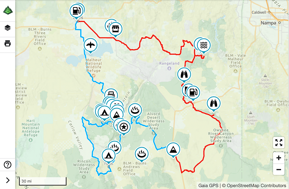
Your adventure begins in Burns, Oregon, made infamous by the Bundy Brothers, who led a 41-day occupation at Malheur Wildlife Refuge in 2016. This is rugged, wild, ranching country, where cattle outnumber the local population by 14 to 1. The first discovery point along the route is at Malheur Lake (DP1), a major migratory stop and breeding ground for over 300 species of fowl. This first section of the route follows a series of paved county roads until reaching the dirt at Moon Hill Road (DP2). Moon Hill is a fantastic way to experience Steens Mountain, as it sees little traffic and offers impressive views as you climb higher and higher. Just note that the road can get bumpy depending on seasonal weather patterns!
There’s a trio of nice campgrounds near the top before reaching Kiger Gorge. Kiger Gorge (DP3) is the largest of the four glacier-carved gorges on Steens Mountain, and the short out-and-back drive to the viewpoint is definitely worth it. Both the East Rim Lookout (DP4) and Steens Mountain (DP5) provide stunning 360-degree views, especially of the Alvord Desert 5,000 feet below.
From Steens Mountain, descend down the gravel road to the old Riddle Brothers ranch and homestead (DP6). There are several old ranch buildings still standing and a hiking trail if you’d like to venture out further on foot. Jump back on the pavement heading south to Fields Station (you’d be wise to fuel up here!), before heading over to Borax Hot Springs (DP7). While Borax Hot Springs and its lake may not be safe for soaking, the geothermal activity is impressive. From Borax, head north along the graded dirt road until reaching the Alvord Desert (DP8). At five miles across and ten miles long, the Alvord may not be as large as Black Rock’s playa, but the juxtaposition of the rugged Steens Mountain against the pale lakebed of the Alvord Desert creates an unforgettable scene—and it’s a fantastic place to camp as well. If you’re looking for a soak, try the Alvord Hot Springs right around the corner (just make sure to bring cash; last we checked, it was only $5).
The route continues north into the rugged canyons and plateaus of the northern Alvord Desert, looping around Mickey Hot Springs (DP10, also not safe for soaking) before ending at Highway 95. Those looking to extend their adventure by several days should check out the Alternative Routes for the nearly 300-mile-long Owyhee Canyonlands West track.
Terms of Use: Should you decide to travel a route that is published on Overlandtrailguides.com, you do so at your own risk. Always take the appropriate precautions when planning and traveling, including checking the current local weather, permit requirements, trail/road conditions, and land/road closures. While traveling, obey all public and private land use restrictions and rules, and carry the appropriate safety, recovery, and navigational equipment. The information found on this site is simply a planning resource to be used as a point of inspiration in conjunction with your own due-diligence. In spite of the fact that this route, associated GPS track (GPX and maps), and all route guidelines were prepared under diligent research by Overland Trail Guides, the route accuracy and current conditions of roads and trails cannot be guaranteed.


We just did part of this route. The Steens don't open until June usually so they were still closed when we ran it so we ended up adding Hart Mountain on instead which has some great and free hot springs. Also, the Alvord Playa was still wet in spots so we decided to stay off of it so we could avoid getting stuck. If you are going to fields station it's worth checking what time they close the kitchen. We almost made it but they closed the kitchen before they had fully closed. We documented our adventure on our Wide Open Roams YouTube channel if you are planning on doing this route. https://youtu.be/DyC3F2MhiCE