
The Bush Chicken Adventure Tour
- OTG Crew

- Dec 11, 2025
- 5 min read
Updated: Dec 23, 2025
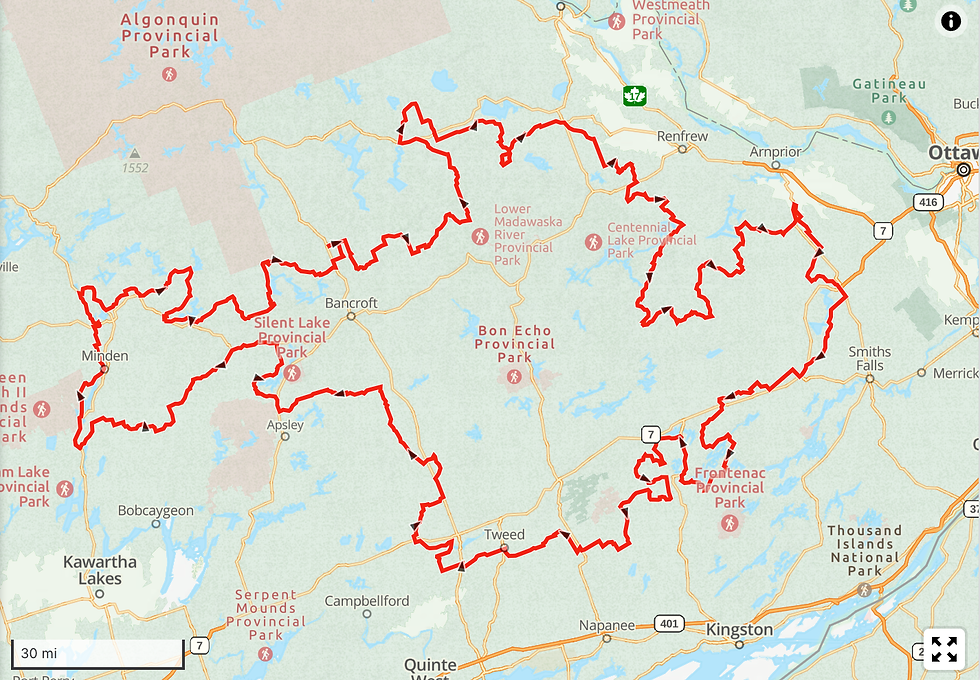
The The Bush Chicken is a 730-mile backroad route through Ontario's Highlands, connecting Haliburton, Renfrew, Lanark, and Hastings counties. Featuring a 60/40 mix of gravel and pavement, the track winds through the Canadian Shield, passing key historic sites like the Marmora Mine, Five Span Bridge, and Bonnechere Caves while offering challenging driving terrain.

Route Overview

Route Contributor
Ride the Highlands is an organization dedicated to promoting exciting motorcycle and adventure touring routes throughout the beautiful Highlands area of Ontario. Their primary goal is to encourage riders to explore the region's diverse landscapes and backcountry roads. Overland Trail Guides is pleased to feature some of their expertly curated routes to offer our customers incredible off-road experiences.
Trip Length & Season
Adventure Rating: Baja Trip Length: 732 miles, 5-10 days Season: May thru October, while the shoulder seasons of spring and fall tend to provide the best riding conditions.
Digital Maps & GPX Files
Download Digital Mapping Files
If you need help working with digital mapping and GPX files, please check out our FAQ section.
Technical Ratings & Terrain
Avg Technical Rating: 1
Peak Technical Rating: 2
Typical Terrain: Approximately 60% dirt/gravel and 40% twisty pavement primarily through backroads. Expect forest roads, hidden two-track, and remote stretches that wind through the wild edge of Ontario’s Highlands. Beware, the gravel roads of the Highlands can turn into a thick snotty mess after moderate to heavy rain.
Recommended Vehicle / Moto / Adventure Vans
Recommended Vehicle: Stock 4x4
Recommended Moto: Big or mid-sized bike.
Adventure Vans: Sprinters and Transits are good to go!
Fuel, Provisions, and Recommended Gear
Fuel: Fuel is readily accessible along the route, and typically never more than 40 miles away. Provisions: Provisions can be obtained in the same general vicinity as fuel. Gear: n/a
Alternative Routes
n/a
Camping Recommendations
We've marked numerous dispersed campsites on Crown Land. Most of these sites tend to be private and tucked away in the woods. If you're looking for options with better views and amenities (fire ring, picnic table, water), consider one of the campgrounds listed below.
Silent Lake Provincial Park campgrounds
Hardwood Hills Campground (Bon Echo Prov. Park)
Silver Lake Provincial Park campgrounds
Lake St Peter Campground
Thompson's Black Rock Park
Discovery Points
Gull River
Minden River Walk
Buttermilk Falls Dam
Haliburton Highland Museum
Drag River
Haliliburton
Canadian National 2616 Steam Train
York River
Fosters Lake Park
Little Missippi River
Madawaska River
Rockingham Church
Rockingham Falls
Zurakowski Park
Barry's Bay
Kashub Heritage Park
Bonnechere River
Eganville
Fourth chute (waterfall)
Bonnechere Caves
Barnet Park
Calabogie Lake
Clyde River
Blueberry Mountain Viewpoint
Tatlock Quarry
Fulton's Sugar Bush & Maple Shop
Mississippi River
Five Span Bridge Park
Five Span Bridge
Almonte
Mississippi Valley Textile Museum
Carleton Place
Perth
Last Duel Park
Historic Erinsville Train Station
Moira River
Tweed Jailhouse
Marmora Mine
Burnt River
Land Managers & Other Resources
n/a
Permits & Papers
n/a
Route Details
The Bush Chicken track traverses the rugged topography of the Ontario Highlands, a region defined by the geological transition between the southern edge of the Canadian Shield and the Saint Lawrence Lowlands. While the name may solicit a chuckle—referencing the Ruffed Grouse often seen bursting unpredictably from the roadside vegetation—the route itself offers a comprehensive survey of the province’s backroads. The loop covers roughly 730 miles and acts as a connector for several smaller, well-known tracks in the region. The surface composition is approximately 60% gravel and 40% pavement, though the character of the unpaved sections varies significantly depending on recent grading and weather conditions. Visitors should expect a mix of hard-packed gravel, twisty tarmac, and loose surfaces that require moderate attention. While the loop can be traveled in any direction, a clockwise progression from the Haliburton area allows for a logical flow through the changing landscapes of Renfrew, Lanark, and Hastings counties.
The western portion of the track winds through the Haliburton Highlands, an area characterized by dense deciduous forests and a high concentration of waterways. Navigating out of the town of Minden, the route follows the contours of the Gull River before intersecting with the Drag River. The terrain here is classic Canadian Shield: rolling granite hills interspersed with lakes and wetlands. Travelers will pass the Haliburton Highlands Museum (discovery point) before pressing deeper into the woods towards the Buttermilk Falls Dam (discovery point). The roads in this sector are generally wide and well-maintained, but the dense tree cover can retain moisture, creating slick spots in shadowed corners. As you push northward, the track enters the Madawaska Valley. This area serves as a cultural and geological distinct point, marked by the settlement of Barry's Bay. Here, history buffs can stop at the Kashub Heritage Park (discovery point) or the Zurakowski Park (discovery point) to understand the early European settlement patterns of the region.
Transitioning from the highlands down toward the Ottawa Valley, the route passes through a corridor rich in geological features. The Bonnechere River serves as a guide for a portion of the track, leading travelers past the Bonnechere Caves (discovery point) and the scenic Fourth Chute. The architecture in this region shifts as well, visible in the preservation of the Rockingham Church (discovery point). As the track turns eastward into the Calabogie region, the terrain becomes arguably the most technical. The elevation changes around Calabogie Lake offer engaging driving, but one must be wary of the road surface. These roads are often treated with calcium chloride for dust control; when mixed with rain, this creates a surface with the consistency of "baby poo"—a local colloquialism for a slick, clay-like slurry that offers very little traction. Caution is advised during or immediately after precipitation.
The eastern and southern legs of the journey bring travelers into Lanark and Frontenac counties, where the rugged shield rock begins to give way to agricultural land and limestone plains. The water crossings become more significant here, including the Mississippi River and the Clyde River. A notable architectural feature on this leg is the Five Span Bridge (discovery point) in Pakenham, a rare stone masonry structure that stands out against the rural backdrop. Passing through the town of Almonte, the Mississippi Valley Textile Museum (discovery point) offers context on the industrial history that shaped these riverside towns. As the route curves south and then west to close the loop, it traverses the industrial scars and historical remnants of Hastings County. The massive open pit of the Marmora Mine (discovery point) dominates the landscape near the town of Marmora, a stark contrast to the natural beauty seen earlier in the trip. The track eventually winds through Tweed, home to the historic Tweed Jailhouse (discovery point), and follows the Moira River before returning to the shield country, completing the circuit.
Terms of Use: Should you decide to travel a route that is published on Overlandtrailguides.com, you do so at your own risk. Always take the appropriate precautions when planning and traveling, including checking the current local weather, permit requirements, trail/road conditions, and land/road closures. While traveling, obey all public and private land use restrictions and rules, and carry the appropriate safety, recovery, and navigational equipment. The information found on this site is simply a planning resource to be used as a point of inspiration in conjunction with your own due-diligence. In spite of the fact that this route, associated GPS track (GPX and maps), and all route guidelines were prepared under diligent research by OverlandTrailGuides.com, the route accuracy and current conditions of roads and trails cannot be guaranteed.


Comments