
The Lost Sierra 4x4 Trail
- OTG Crew
- Jul 8, 2021
- 9 min read
Updated: Feb 1
An hour's drive north of Lake Tahoe lies a magical place known to locals simply as the Lost Sierra. The Lost Sierra was once home to some of the most prosperous gold districts in the country. Today people come to enjoy its alpine lakes, craggy mountain buttes, and to explore the remnants of its pioneer past.
Route Overview
Trip Length & Season
Adventure Rating: Epic
Trip Length: 204 miles, 4-8 days
Season: June - November (check with the local National Forest for snow conditions).
Digital Maps & GPX Files
Download Digital Mapping Files
If you need help working with digital mapping and GPX files, please check out our FAQ section.

Technical Ratings & Terrain
Avg Trail Rating: 2-3 Peak Trail Rating: 5
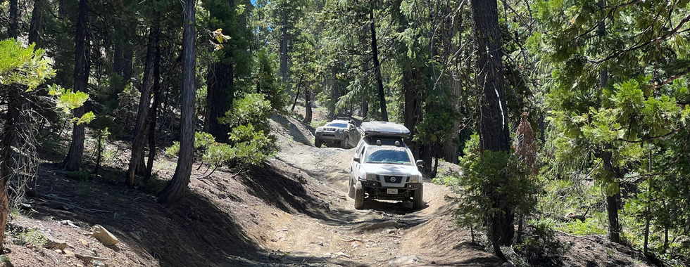
Typical Terrain: Graded forest service roads, numerous rocky jeep tracks, a few shelf roads with a lot of exposure, and some connecting pavement. Inexperienced off roaders will benefit from a spotter for trails like Poker Flat.
Recommended Vehicle / Moto / Adventure Vans
Recommended Vehicle: High clearance 4x4
Recommended Moto: A mid-weight or dual sport bike is recommended given the amount of moderate terrain.
Adventure Vans: Transits & Sprinters are not recommended.
Fuel, Provisions, and Recommended Gear
Fuel: There are numerous fuel stops along this route. Fuel typically isn't further than 100 miles away. Places to refuel include Tucson near the beginning of the route, Picture Rocks, north of East Sasco Drive (Interstate 10), Oracle, San Manuel, and Tanque Verde. Provisions: Provisions can be obtained in the same general vicinity as fuel. Gear: no specialized gear is recommended for this adventure.
Alternative Routes
Snake Lake
Distance: 11 miles
Technical Rating: 6-7
Those seeking to test their mettle on some more technical jeep trails should try their hand at the Snake Lake loop. If you plan to attempt Snake Lake, a high clearance 4x4 with sliders/armor and a spotter is recommended. Stock vehicles are not recommended! If bird watching is your thing, consider heading on over to Sierra Valley, which happens to be the headwaters of the Feather River and one of the largest wetlands within the Sierra Nevada and a favorite stopping point for migratory birds. Most of the route to and from Sierra Valley is paved, with a short section of dirt as you cross the valley. Both sunsets and sunrises are amazing, and the sky is painted in various hues of orange, red and pink, and the surrounding marshlands hum with the chatter and chirping of wild fowl.
Camping Recommendations
Whether you're seeking secluded wilderness camping, fantastic views, or lakefront sites, the Lost Sierra has it all. Just keep in mind the developed campgrounds along Gold Lake Highway are rather popular and can be difficult to snag a site on weekends. Dispersed camping is permitted throughout the main route, unless marked otherwise. Some of our favorite sites and locations include:
St Louis Bridge vicinity
McRae Meadows
Lakes Basin Viewpoint (DP11)
Church Creek Meadows area
Gold Lake 4x4 Camp
Little Gold Lake
Lots A Lakes OHV Trail
Wild Plum Campground
Discovery Points
DP1 - Poverty Hill Diggins
DP2 - Port Wine Twin Bridges
DP3 - La Porte Cemetery
DP4 - La Porte
DP5 - Old St Louis Bridge
DP6 - Eureka Tunnel
DP7 - Howland Flat
DP8 - Poker Flat Road
DP9 - Sawmill Ridge Warming Hut
DP10 - Mt Fillmore
DP11 - Lakes Basin Viewpoint
DP12 - Spencer Lakes
DP13 - Jamison Mine Complex
DP14 - Mohawk Stamp Mill
DP15 - Plumas-Eureka Mining Musem
DP16 - Middle Fork Feather River
DP17 - Frazier Falls
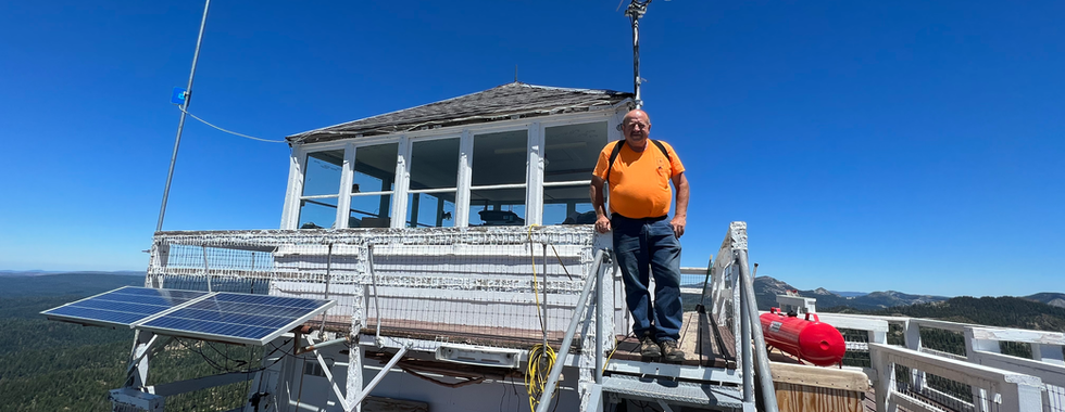
DP18 - Mills Peak Fire Lookout
DP19 - Upper Sardine Lake
DP20 - Gold Lake
DP21 - Lakes Basin Viewpoint #2
DP22 - Tamarack Lakes
DP23 - Sierra Buttes Fire Lookout
DP24 - Sierra City
DP25 - Kentucky Mine Museum
DP26 - Downieville
DP27 - North Fork Yuba River
DP28 - Cannon Point
DP29 - Forest City Ghost Town
DP30 - Alleghany
DP31 - Saddleback Fire Lookout
DP32 - Eureka Diggins
Land Managers & Other Resources
Permits & Papers
Fees If you plan to visit Plumas-Eureka State Park, there is a day use fee.
Adventure Badge
OTG has partnered with All Roads Taken to offer an adventure badge for this route.
>> Buy your adventure badge today!

Route Details
Not long after the reporting of gold in the New York Herald kicked off the California Gold Rush, a number of boomtowns popped up shortly thereafter in the ore rich foothills and mountains of the Sierra Nevada. Many of the country's most productive gold mining districts were found in the Northern Sierra. Downieville, Grass Valley, La Porte, and the Alleghany mining districts were among those with the greatest gold yields. While the number of active mining operations has decreased dramatically since the hey-day of mining in the second half of the 19th century, the remnants of these early pioneers can be found in living villages and towns, as well as abandoned mines, homesteads, and ghost towns throughout the backcountry. For decades crowds have flocked to Lake Tahoe and the central Sierra, and the exquisite ruggedness of Yosemite, Kings Canyon, and the eastern Sierra. And while anglers, hikers, and horse people have long recreated in the northern Sierra, it was the mountain bike crowd that really started turning outsiders on to the unspoiled grandeur of northern Sierra, a region that has come to be known as The Lost Sierra. Towering thousands of feet above Sierra City and Lakes Basin Recreation Area, the Sierra Buttes are the crown jewel of the Lost Sierra with their craggy buttes and gem of a lookout tower. And while the Lost Sierra region extends north to the Feather River, the Lost Sierra Trail explores the heart of this beautiful backcountry and wilderness-- exploring old gold fields and diggings, abandoned mines, ghost towns, pioneer cemeteries, rocky jeep trails, pristine alpine meadows and lakes, and fantastic views atop three different fire lookouts. For those that wish to explore more of the lost Sierra Region, check out the 167 mile Plumas Backcountry Discovery Trail that snakes its way north of the Feather River until it meets its terminus at the Lassen National Forest.
We begin our adventure a few miles from the old mining town of La Porte, along the manicured dirt of Scales Road. That creek you'll be soon be passing over is Slate Creek, that was once rich with gold ore and supported a number of mining camps along its banks and its tributaries. For the next 30 or so miles, Slate Creek is the constant waterway that you'll be criss-crossing over a number of times. And just like that, you'll be at your first discovery point, the Poverty Hill diggings. Hydraulic mining was used extensively in the Poverty Hill, in addition to other surrounding mining districts. The catastrophic effects of past hydraulic mining is still evident today, with entire hillsides lay bare, mounds of gravel and mine tailings, and pools of wastewater. Despite its name, the Poverty Hill district produced a healthy amount of gold ore. As you make your way through the backcountry, you'll notice many more gravel mounds and mine tailings scattered about the woods. A few miles to the north lies the old Port Wine district, with more obvious remnants of diggings. Take the rather picturesque old steel Port Wine Twin Bridges (DP2) across Slate Creek, which brings you to the still inhabited village of La Porte. The old La Porte Cemetery (DP3) keeps many of the early pioneers in their permanent resting place, and is certainly worth a quick visit. Next you'll head east through the old mining camps of St Louis and Howland Flat. The old St Louis concrete bridge (DP5, built 1913) is a great place to stop for a break with easy access to the creek at the campsite. Notice the giant tunnel across from the bridge. Miners had rerouted Slate Creek by blasting a hole through the rock after mining tailings had blocked the creeks natural passage. The forest through this part of the route is thick, healthy and beautiful. But within the shadows of the forest, lies one of the best remaining ghost towns within the Lost Sierra; Howland Flat (DP7). Numerous old houses and buildings still remain in varying states of decay. It is the creep yet well preserved cemetery that is the highland of Howland Flat for many. In its heyday (1870s), Howland Flat was home to 1,500 people, saloons, a hotel, church, school, and Wells Fargo Express Office. Just around the corner is the old townsite of Potosi (not much to see compared to Howland Flat).
Up to Howland Flat, the dirt roads have been relatively tame, that's about to change. Poker Flat Road, is full of rocks, and o
ne tricky creek crossing that may require a spotter for novice off road drivers. Poker Flat provides a bit of a challenge, and some changing scenery compared to previous miles traveled. Poker Flat eventually joins Johnsville-McRae Road into some really beautiful country. Make sure you stop to snap some photos along the way.
Views of Mt Fillmore and Mt Etna can be had as you make your way towards Plumas-Eureka State Park. McRae Meadows is another great resting point, and contains a number of campsites suitable for small groups. From McRae Meadows head on up the mountain and over to Spencer Lakes. See if you can spot the A-tree along the way. The Lakes Basin Viewpoint (DP11) provides exquisite views of Mt Elwell and the surrouding Lakes Basin area. Spencer Lake is a rather mild jeep trail, and does require a short hike to the lakes where the jeep trail ends.
From Spencer Lakes backtrack until you're back on Johnsville-McRae Road, which is a rather bumpy affair as you descend into Plumas-Eureka State Park (SP). But the views of the canyon are spectacular as you drop in elevation. But be forewarned, you're dropping into the heart of the Lakes Basin Recreation Area, which is full of developed campgrounds and day trippers. Expect to see a lot more people and vehicles once you make it down it down to the Plumas-Eurekea Mining Museum (DP15). Plumas-Eureka SP has a number of well preserved buildings and the museum (which is free) provides a wealth of information about the mining operations and surrounding area. Burn the pavement over through Graeagle (be sure to refuel!) and make your way to Frazier Falls (DP17). A 1 mile paved path leads to an exquisite viewing platform, with nearly all of the 248' of the cascading falls in view. Next you'll take a quick jaunt up Mills Peak (DP18), which features the first of three fire lookouts, all with great views of the northern Sierra. Follow the dirt backroads back to Gold Lake Highway and head over to Sardine Lake. The views of the Sierra Buttes from upper Sardine Lake are northing short of magical, and a visit near sunset is absolutely sublime. Take the highway and skip on over to Gold Lake.
Gold Lake is the largest lake and most frequented lake within Lakes Basin. It serves as the epic center for many camping or visiting the area, and is also a favorite basecamp for the off road crowd. If you plan on staying at Gold Lake, we recommend trying to snag a spot at one of the lakeside sites at the Gold Lake 4x4 camp. Gold Lake Road can be rocky and loose at times, and we'd qualify it as mildly technical, but the views keep on getting better the higher up you drive. The Lots A Lakes OHV Trail is another fun jeep trail that has quite a few bumps, and maybe even a few mildly technical sections. But man oh man, the views up here are fantastic and there are a number of great places to camp as well. Head on over for a quick trip to Tamarack Lakes, which has some really impressive up close views of the Sierra Buttes. And just when you thought things couldn't get any better, follow the increasingly steep dirt roads up a series of switchbacks up to the Sierra Buttes Lookout (DP23, elev. 8,857'). You'll need to park your vehicle and climb a series of stairs, but the views from the top are second-to-none!
They say what goes up must come down, which is certainly true given your location atop the highest point within the Lost Sierra region. The dirt road gives way to a steep and loose jeep track with views of the deep canyon carved by the North Yuba River. The old and prosperous mining town of Sierra City sits at the canyon's bottom, and from here you'll follow Highway 49 for about a dozen miles until reaching the seat of Sierra County, Downieville. Downieville is a quaint village with a well kept downtown that is beaming with gleeful mountain bikers. A favorite swimming spot happens to be right in the center of town below the old steel bridge. from Downieville you'll head over to the old Forest City ghost town (DP29) that was within one of California's richest mining districts, the Alleghany Mining District. A few dozen folks still live in Alleghany, which is also home to the district's most prosperous mine, the Sixteen-to-one mine.
The final leg of the journey descends down the mountain back to the highway at Goodyear's Bar, before crossing the pavement and climbing up the narrow dirt roads up Saddleback Mountain. At the top of Saddleback, you'll reach your third and and final lookout (DP31, Saddleback Fire Lookout). The route concludes by snaking down the mountain, past the old Eureka Diggings (DP32), until reaching the rural outpost of Cal-Ida and Highway 49.
Gallery


Terms of Use: Should you decide to travel a route that is published on Overlandtrailguides.com, you do so at your own risk. Always take the appropriate precautions when planning and traveling, including checking the current local weather, permit requirements, trail/road conditions, and land/road closures. While traveling, obey all public and private land use restrictions and rules, and carry the appropriate safety, recovery, and navigational equipment. The information found on this site is simply a planning resource to be used as a point of inspiration in conjunction with your own due-diligence. In spite of the fact that this route, associated GPS track (GPX and maps), and all route guidelines were prepared under diligent research by Overland Trail Guides, the route accuracy and current conditions of roads and trails cannot be guaranteed.