
Sedona Backcountry Trail
- OTG Crew
- Feb 25, 2021
- 8 min read
Updated: Dec 23, 2025
Explore the Red Rocks and allure of Sedona's canyon country. Deep into the mountains and overlooking Sedona and the Verde Valley region, the Sedona Backcountry Trail provides the perfect mix of recreation, relaxation and rejuvenation.
ROUTE OVERVIEW
Trip Length & Season
Adventure Rating: Epic
Trip Length: 250 miles, 4-7 days
Season: May - November. High elevation roads/trails towards the Flagstaff area may open earlier depending on seasonal snowpack. Coconino National Forest does close some trails such as Schnebly Hill after heavy rains. Check the Coconino NF Road Status page for road closures.
Digital Maps & GPX Files
Download Digital Mapping Files
If you need help working with digital mapping and GPX files, please check out our FAQ section.

Technical Ratings & Terrain
Avg Technical Rating: 2
Peak Technical Rating: 4
Typical Terrain: Most of the track consists of well kept graded dirt and gravel roads. However, the track also includes a number of rockier and undulating trails like Schnebly Hill, Bunker Hill, Powerlines trail, Outlaw trail, and Dry Creek Road.
Recommended Vehicle / Moto Adventure Vans
Recommended Vehicle: Stock 4x4
Recommended Moto: Given some of the rockier sections along this track (especially the start at Schnebly Hill), we recommend a mid-sized bike.
Adventure Vans: Sprinter 4x4s can handle the vast majority of this track. We recommend using the Munds Park Bypass where Schnebly Hill meets the interstate 17, avoiding the loop around Bunker Hill, road 354 Bypass, then taking the Red Rock bypass to avoid Powerlines and Outlaw Trails, and finally skipping Dry Creek Road.
Fuel, Provisions, and Recommended Gear
Fuel: Fuel can be found well within 100 miles of the trail except for the section from Kachina Village to Clarksdale, which is approximately 140 miles between fuel stops but can be reduced by skipping some of the out-and-backs to various lookout points. Provisions: Provisions can be obtained in the same general vicinity as fuel. Gear: no specialized gear is recommended for this adventure.
Alternative Routes
Munds Park Bypass Distance: 13 miles Technical Rating: 1 Sprinters and AWD vehicles should use this section to avoid some of the rockier and tighter trails that circle around Munds Park east of the interstate. This track simply follows the interstate skipping the dirt.
Casner Mountain Trail (requires free permit) Distance: 7 miles Technical Rating: 4 Casner Mountain is a rocky and steep track with a number of switchbacks. Casnmer mountain can be used to bypass the western portions of the larger loop around Sycamore Point and out through Jereome. A stock 4x4 or mid-sized bike is recommended. For more info about obtaining a permit please visit Coconino NF.
Road 354 Bypass
Distance: 25 miles
Technical Rating: 1
Road 354 that descends down the plateau to Perkinsville is a notoriously rocky trail that is prone to washouts. Full sized rigs, Sprinter Vans, and especially oversized rigs (like Earth Cruisers) should consider taking this bypass. In fact, you can expect this to be the slowest going section of the trail.
Red Rock Bypass Distance: 9 miles Technical Rating: 1 Just like the Munds Park, this track should be used by Sprinter 4x4s and AWD vehicles that wish to skip the moderate Powerlines and Outlaw Trails. Lifted AWD vehicles with larger tires (not vans) may be able to take on these trails. Broken Arrow Distance: 9 miles
Technical Rating: 5 Broken Arrow is one of the most popular OHV trails in the Sedona Basin, and will take folks to the final discovery point at Chicken Point. You'll need a 4x4, lift, and at least 32" tires. Be prepared to take on the white knuckle descent down the Devil's Staircase though!
Camping Recommendations
Dispersed camping is not permitted in much of the Sedona basin in Coconino National Forest's Red Rock Ranger district. Outside of developed campgrounds in the Red Rock Ranger District, there are 8 designated dispersed camping areas (south of the Red Canyon Overlook) that are available for free on a first come, first serve basis. Dispersed camping is permitted on National Forest Lands outside of the Red Rock Ranger District. Some of our favorite places to camp along the route include:
Above Shnebly Hill (dozens of beautiful campsites in the pines on the way to the interstate)
East Buzzard Point (you'll likely have the place to yourself)
Edge of the World (can get busy) and the various campsites off of road 231
Sycamore Point vicinity (explore the various side roads/trails)
Discovery Points
DP1 - Merry Go Round Rock
DP2 - Schnebly Hill Overlook
DP3 - East Buzzard Point
DP4 - East Pocket Lookout Tower
DP5 - Edge of the World
DP6 - Rattlesnake Mesa
DP7 - Bunker Hill
DP8 - Secret Mountain Vista
DP9 - Turkey Butte Lookout
DP10 - Great Western Trail
DP11 - Sycamore Falls
DP12 - Sunflower Flat Wildlife Area
DP13 - Sycamore Point
DP14 - JD Dam wildlife area
DP15 - Lake Pocket Viewpoint
DP16 - Perkinsville Bridge
DP17 - Gold King Mine & Ghost Town
DP18 - United Verde Mine
DP19 - Jerome
DP20 - Tuzigoot Ancient Pueblo
DP21 - Verde River
DP22 - Powerline Trail
DP23 - Robbers Roost Hideout Cave
DP24 - Outlaw Trail
DP25 - Honanki Heritage Site
DP26 - Red Canyon Overlook
DP27 - Palatki Heritage Site
DP28 - Fay Canyon Arch
DP29 - Boyton Pass Vortax
DP30 - Dry Creek Road
DP31 - Van Deren Cabin
DP32 - Broken Arrow Trail
DP33 - Chicken Point
Land Managers & Other Resources
Permits & Papers
There is a fee (but your National Park American the beautiful pass will work) at Native American Heritage Sites like Tuzigoot, Honanki and Polatki. You may visit the gift shop at Gold King Mine and Ghost Town for free, but the tour does entail a small fee. If you plan to leave your vehicle unattended while recreating on Coconino National Forest forest land around Sedona or Oak Creek Canyon, you'll need to obtain a Red Rock Pass. To obtain a free permit for Casner Mountain Trail, please visit Coconino NF's website.
Adventure Badge OTG has partnered with All Roads Taken to offer an adventure badge for this route. >> Buy your adventure badge today!

Route Details
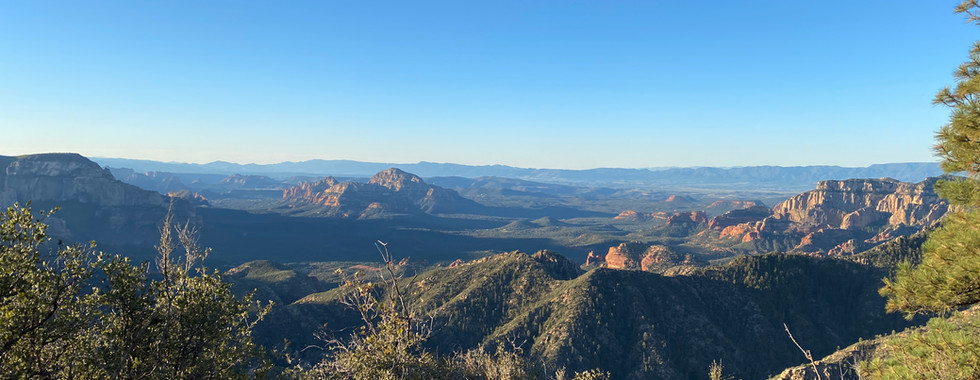
Red Rock country—a place where new age and spiritual types, hikers, mountain bikers, off-roaders, and backpackers flock in search of recreation, relaxation, and rejuvenation. And done correctly, there's really no reason you can't achieve all three on your next trip to Sedona. But here's the thing: the streets and trails (whether they're hiking, mountain biking, or OHV) in the Red Rock district—the basin that surrounds Sedona—are typically packed with people on any given day, especially the weekends! That's why we opted to create a route that does its best to explore the surrounding mountains and backcountry, where you won't come across throngs of tourists in Pink Jeeps and 20-Jeep caravans taking on Broken Arrow Trail (though it is still a rad and worthwhile trail).
We begin our adventure in the town of Sedona and make our way up Schnebly Hill. Schnebly Hill does see quite a bit of off-road traffic (including Pink Jeeps), but the views on the way up are simply incredible. There are so many fantastic hikes around Sedona that it's hard to make a top 5 list just because so many are of such a high caliber. However, if you've brought your mountain bike along, Hangover Trail on the way up Schnebly Hill is one of the best (and most technical) trails in Sedona. Your first discovery point is at Merry Go Round Rock, a favorite stopping point for hikers and off-roaders heading up the mountain. Once you reach the top of Schnebly Hill and head over to Schnebly Hill Overlook (DP 2), you'll get an idea of what lies ahead—views, views, and more views of Sedona's stunning red rock bluffs, canyons, and mesas. And there's more good news: once you've made it up Schnebly Hill, there's a ton of dispersed camping in the Coconino and Kaibab National Forests (unlike the Coconino Red Rock district below, where dispersed camping is prohibited).
From Schnebly Hill, you'll drive along a series of dirt roads across Interstate 17 and around Munds Park before arriving back at the Interstate at Kachina Village. If you're not carrying extra fuel, we strongly recommend fueling up, as the next opportunity for fuel and supplies is in Cottonwood, towards the end of the route. From Kachina Village, the route begins to ascend, and you'll top out at over 7,000 feet as you make your way to the edge of the canyon walls at East Pocket. The views from the East Pocket Lookout Tower (DP 4) and the surrounding area are typical Sedona: surreal, stunning, epic, breathtaking—choose your favorite adjective! As you make your way West, the route is littered with dozens of viewpoints and campsites; just keep in mind that many of these sites don't provide much shelter against the wind.
If you're looking to set out on two feet in search of incredible vistas, then you'll want to check out Secret Mountain Trail. With Sedona and Coconino's extensive trail networks, you can make this a quick 30-minute hike or an all-day adventure. For those seeking more technical trails, consider checking out Casner Mountain Trail (requires a permit from Coconino NF), which is a steep, rocky, and loose jeep track that descends to the Red Rock district (Sedona basin). Once you've reached the viewpoint at Bunker Hill (DP 7), the route makes its way to the west side of Sedona Canyon Country. Sycamore Falls (DP 11), surrounded by stands of tall pines, feels more like Flagstaff than Sedona, but the quick hike definitely pays its share of dividends. And just around the corner sits Sunflower Flat, a favorite local spot for viewing migratory birds. This leg of the route along the western reaches of Sedona wraps up with views from atop the mesas and canyons (Sycamore Point DP 13 and Lake Pocket DP 14).
Departing from Lake Pocket, the route begins to gradually descend Road 354 and trades in canyon country for the old west. Road 354 is a notoriously rocky and bumpy section of trail that is prone to washouts. Full-size and oversized rigs and adventure vans (like Transits and Sprinters) may wish to skip this section, which typically takes 2 hours to complete (see Road 354 bypass under alternate routes). Once you wrap up Road 354, you'll drive over the old trestles of the Perkinsville Bridge (DP 15) and further down the mountain through the old mining town of Jerome, which still has many relics and historic landmarks from times that have come and gone. Back in the Red Rock district, you can expect more vehicle traffic on the trails. This section of the route visits three well-preserved aboriginal sites, including the old pueblo ruins at Tuzigoot National Monument (DP 16), and the cliff dwellings at the Honanki (DP 18) and Palatki Heritage sites (DP 19). The Sinagua people, the ancestral relatives of the Hopi, built these dwellings between the 10th and 12th centuries—nearly 1,000 years ago! Prior to reaching the two Sinagua heritage sites, another fantastic hike awaits. Robbers Roost is said to be the old hideout of bandits and bootleggers who used the cave to elude local lawmen. It's said that local shamans (it's sometimes referred to as Shaman's Cave) are known to still use the caves for shamanistic rituals.
The final leg of the route runs Dry Creek Road, a mildly technical and bumpy out-and-back that also happens to be quite scenic. There are numerous side options to test the technical capabilities of your rig should you choose. Backtrack Dry Creek Road, where the route concludes in West Sedona. While this is the official terminus of the route, just around the corner sits the Seven Sacred Pools and Soldier Arch and Cave, which are on par with the recommended hikes and discovery points featured in this route and would be a great way to fill your itinerary if you've got daylight to burn.
Gallery


Terms of Use: Should you decide to travel a route that is published on Overlandtrailguides.com, you do so at your own risk. Always take the appropriate precautions when planning and traveling, including checking the current local weather, permit requirements, trail/road conditions, and land/road closures. While traveling, obey all public and private land use restrictions and rules, and carry the appropriate safety, recovery, and navigational equipment. The information found on this site is simply a planning resource to be used as a point of inspiration in conjunction with your own due-diligence. In spite of the fact that this route, associated GPS track (GPX and maps), and all route guidelines were prepared under diligent research by Overland Trail Guides, the route accuracy and current conditions of roads and trails cannot be guaranteed.