
Hells Canyon Adventure Trail
- OTG Crew

- Aug 23, 2023
- 7 min read
Updated: Nov 7, 2024
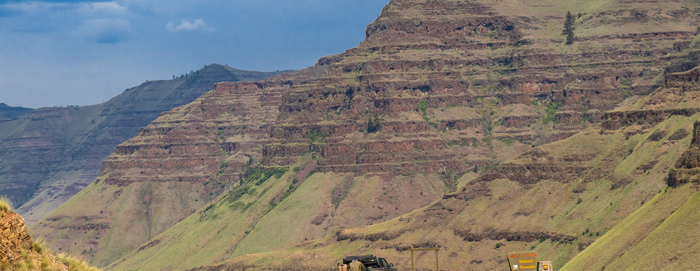
At 8,000 feet deep, Hells Canyon is the deepest canyon in North America. The Snake River bisects the rugged volcanic landscape in one of the most pristine and picturesque locations in the Pacific Northwest. If you're seeking wild rivers, an abundance of wildlife, snowcapped alpine peaks, dark and rugged canyons, and dispersed camping galore, the HellCAT is your ticket!


All photos courtesy of Adventure Taco.
Route Overview
Trip Length & Season
Adventure Rating: Epic Trip Length: 368 miles, 4-8 days Season: Recommended June thru October to early November, but may vary depending on snow at higher elevation. The road from Hat Point to Lord Flat is subject to seasonal closures, and is typically closed from Late August through November.
Digital Maps & GPX Files
Download Digital Mapping Files
If you need help working with digital mapping and GPX files, please check out our FAQ section.

Technical Ratings & Terrain
Avg Technical Rating: 1-2
Peak Technical Rating: 3
Typical Terrain: The vast majority of the main track consists of well graded dirt forest roads.
Recommended Vehicle / Moto / Adventure Vans
Recommended Vehicle: Stock 4x4
Recommended Moto: Big bikes and mid-weight bikes should be able to tackle this track.
Adventure Vans: Sprinter 4x4s are good to go on the main track.
Fuel, Provisions, and Recommended Gear
Fuel: 125 miles from Council to Scotty's just south of Oxbow, 255 miles from Scotty's to Enterprise. Keep in mind, if you do the alternative tracks, you'll need to carry extra fuel. For motos with limited fuel range, consider taking the pavement from Imnaha back to Enterprise, or you can continue to the Zumwalt Prairie Reserve and take Zumwalt-Buckhorn Road. Both of those options are under 100 miles from the gas station south of Oxbow. Provisions: Provisions can typically be obtained in the same general vicinity as fuel. Gear: no specialized gear is recommended for this adventure.
Alternative Routes
Dug Bar
Distance: 60 miles out-and-back
Technical Rating: 2 The Dug Bar track leads to the historic Dug Bar Ranch (DP A), which sits on the Snake River. The track follows the Imnaha River for a good chunk of the way to Dug Bar, until it climbs up and over the mountains to drop into the Snake River drainage. More adventurous folks may wish to follow the Imnaha Trail (from Cow Creek Camp) out to the Snake River and to Eureka Bar. Those lucky enough to make the to Dug Bar will be rewarded with the opportunity to explore the old Dug Bar Ranch. Dug Bar features a working airstrip, so please choose your camp away from the landing strip.
Camping Recommendations
Hells Canyon is blessed with some of the best dispersed camping in the lower 48. There are literally thousands of fantastic dispersed sites spread throughout the area. Some of our favorite places to camp include:
Black Lake Campground
McGraw Lookout (viscinity)
Lord Flat
Cow Creek Camp
Dug Bar
Zumwalt Prairie
Hat Point
Red Hill Lookout
Discovery Points
DP1 - Weiser River
DP2 - Lost Valley Reservoir
DP3 - Smith Mountain Viewpoint
DP4 - Black Lake
DP5 - Horse Mountain Lookout
DP6 - Kinney Point Viewpoint
DP7 - Sheep Rock
DP8 - Silver Kings Mine
DP9 - Snake River
DP10 - Oxbow
DP11 - Hess Road
DP12 - Hells Canyon Overlook
DP13 - McGraw Lookout
DP14 - Imnaha River
DP15 - Imnaha
DP16 - Granny View Vista
DP17 - Memaloose Airstrip
DP18 - Hat Point Lookout
DP19 - Seven Devils
DP20 - Hells Canyon
DP21 - Dorrance Cow Camp & Cabin
DP22 - Lord Flat
DP23 - Zumwelt Prairie Reserve
DP24 - Duckett Barn
DP25 - Buckhorn Overlook
DP26 - Red Hill Lookout
Alternative Routes Discovery Points
DP A - Dug Bar
Land Managers & Other Resources
Permits & Papers
n/a
Route Details
Hells Canyon is the deepest river gorge in North America. The rugged canyon is 8,000 feet at its maximum depth, and extends 125 miles through Washington, Idaho and Oregon. Birthed hundreds of millions of years ago from a volcanic arc, the Snake River eventually cut a deep canyon through the mountains around 6 million years ago. The Snake River is one of the fast flowing rivers in North America, and is a favorite among recreational paddlers, anglers, and hunters. Hells Canyon NRA (National Recreation Area) has long attracted outdoor recreationalists, given its rugged and scenic mountains and canyons, world class fishing and hunting, hundreds of miles of hiking trails, and otherworldly camping opportunities. The terrain in this corner of eastern Oregon and southern Idaho is so impressive, we're astounded that it hasn't been designated a national park. Despite the rugged terrain of Hells Canyon, the trails over the vast majority of the track are relatively mild mannered. While adventurers who seek out technical and challenging trails may be disappointed, it's the geography and otherworldly views that are the true store of this overland track. The route can be driven in either direction, but for the sake of this guide we begin Council, ID and zig zag our way west towards Enterprise, OR. Take the pavement of Highway 95 north for several miles, and then taking a left onto the dirt towards Lost Valley Reservoir (DP2). The first leg of the track is dominated by hills and rather low lying mountains. The roads are all in relatively good condition, so expect to make good time while traveling, especially since there aren't many locations to stop and see until turning right towards Black Lake.
Once you make the right towards Black Lake, the track begins to ascend quickly and a number of rugged peaks will come into view. The HellCAT (Hells Canyon Adventure Trail) features a number of astounding viewpoints, the first of these can be found at the Smith Mountain Lookout (DP3). The view from smith mountain has impressive views of White Mountain (to the north) and Echols Mountain (to the northeast). As you cotinue on to Black Lake, you'll notice the glacier carved valleys on your left and right. Black Lake (DP4) is a picturesque alpine lake that sits in a deep bowl surrounded by mountains on three sides. It has a reputation for reflecting the surrounding mountains and clouds in the sky when conditions are right, which is an absolutely sublime experience for those lucky enough to witness this phenomenon. Given the views, the campground at Black Lake isn't too shabby either. From Black Lake, backtrack down to where you came. You'll pass the old mining camping of Landore (now jut a place on a map) and head towards Sheep Rock for another out-and-back adventure packed with your first views of Hells Canyon and the Snake River. Views along this stretch of track include Horse Mountain Lookout (DP5), Kinney Point (DP6), and our favorite, Sheep Rock (DP7), which does entail a quick scramble (5 minutes) up the hiking trail to the viewpoint. From Sheep Rock you'll retrace your tracks through the mountain outpost of Cuprum (an old mining town) and down to the Snake River (DP9) at the bottom of Hells Canyon. If you've got plenty of fuel to spare you may consider making the trek northward to the Hells Canyon Visitor Center, but the main track crosses the Snake and begins ascending up Hess Road (DP11). Most folks will want to head a few miles south of Oxbox to refuel and restock provisions as necessary. The views while climbing up Hess Road are really something else. Some of the better views in Hells Canyon are along this next stretch of trail from Hess Road out to McGraw Lookout (DP13). The ruggedness of Hells Canyon is on full display upon reaching the Hells Canyon Overlook (DP12). Looking eastward across the canyon you'll see series of rugged alpine peaks. These are the Seven Devils (DP19), which are often snowcapped through mid-summer. At 9,311 feet, He Devil is the tallest of the Seven Devils. The track retraces it steps and drops down to the Imnaha River Canyon, while while quite scenic, isn't nearly as deep or rugged as Hells Canyon. Continue north following along the bank of the Imnaha River (DP14) for several miles until you reach Imnaha (DP15), which is really nothing more than a few houses and a small store. If your rig is equipped for long distance backcountry travel, we strongly encourage you to check out the Dug Bar alternative track, which is a 60 mile-out-and-back route to the Snake River. Upon reaching Imnaha, the Track once again climbs to the western crest of Hells Canyon. This section of the HellCAT has what we believer are the most exquisite views of Hells Canyon and the Seven Devils. Five Mile Overlook, Horse Creek Overlook, and Granny View Vista (DP16) all provide excellent views of the Imnaha River Canyon. Just around the corner from Granny View is Hat Point (DP18), which may be the most renowned viewpoint in Hells Canyon NRA. From Hat Point continue north towards Lord Flat (the forest service closes this section of road to vehicle travel in late August through November). The road to Lord Flat is the bumpiest of the entire track, but nothing a stock 4x4 can't easily handle. If you're lucky enough to make it to Lord Flat (DP22), be sure to stop at Dorrance Cow Camp and Cabin (DP22). Lord Flat represents the end of the road. Lord Flat also has an operational airstrip that was opened in 1943 and has remained open to commercial and private aviators ever since. If you're lucky enough to visit Lord Flat, be sure to keep your vehicle away from the landing strip given its operational status. The section of track out to Lord Flat also features some of the best, and most remote camping in Hells Canyon.
Upon retracing your steps back to Imnaha, the track begins to climb into the Zumwalt Prairie Preserve (DP23). The larger Zumwalt Prairie covers 330,000 acres and is the largest remaining grassland of its type in North America. The prairie is known for its abundance of wildlife (especially avian species). Sprinttime typically brings an explosion of wildflowers in the prairie's grasslands. The track from the Zumwalt Prairie, past Buckhorn and out to Enterprise primarily consists of wide graded dirt roads. Buckhorn Overlook (DP25) is perhaps the last great overlook in the Hells Canyon vicinity, and also a great place to camp. From Buckhorn, one can easily make it over to Red Hill Lookout (DP26). Take in the views while you can as the track descends down the hills in a few miles before meeting up with the pavement of Highway 3 which leads back to the end of the track at Enterprise, OR.
Terms of Use: Should you decide to travel a route that is published on Overlandtrailguides.com, you do so at your own risk. Always take the appropriate precautions when planning and traveling, including checking the current local weather, permit requirements, trail/road conditions, and land/road closures. While traveling, obey all public and private land use restrictions and rules, and carry the appropriate safety, recovery, and navigational equipment. The information found on this site is simply a planning resource to be used as a point of inspiration in conjunction with your own due-diligence. In spite of the fact that this route, associated GPS track (GPX and maps), and all route guidelines were prepared under diligent research by OverlandTrailGuides.com, the route accuracy and current conditions of roads and trails cannot be guaranteed.


Comments